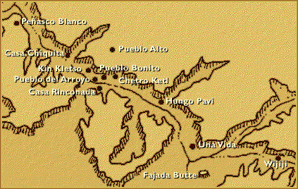
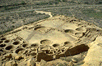
Chaco Canyon, New Mexico
Chaco is remarkable for its monumental public and ceremonial buildings, and its distinctive architecture. To construct the buildings, along with the associated Chacoan roads, ramps, dams, and mounds, required a great deal of well organized and skillful planning, designing, resource gathering, and construction. The Chacoan people combined pre-planned architectural designs, astronomical alignments, geometry, landscaping, and engineering to create an ancient urban center of spectacular public architecture - one that still amazes and inspires us a thousand years later.
The Visitor Center open all year, 8-5, closed on Thanksgiving Day, Christmas Day, and New Year's Day. The park, cultural sites, trails, and campground will remain open on these holidays. 505-786-7014
Directions
Chaco Canyon is located in northwestern New Mexico. The preferred and recommended access route to the park is from the north, via US 550 (formerly NM 44) and County Road (CR) 7900, and CR 7950. From the north, turn off US 550 at CR 7900--3 miles southeast of Nageezi and approximately 50 miles west of Cuba (at mile 112.5). This route is clearly signed from US 550 to the park boundary (21 miles). The route includes 5 miles of paved road (CR 7900) and 16 miles of rough dirt road(CR 7950).
From the south, two routes access Chaco from Highway 9, which runs between Crownpoint, Pueblo Pintado, and Cuba. Both routes can vary from very rough to impassable. Not recommended for RVs.If you are traveling from the south, please call ahead for the latest conditions.